Altimetro – Altimeter Professional MOD APK (Pro Unlocked)
Mod Info
Pro Unlocked
Description
Altimetro – altimeter pro Altimeter professional. Detecting position and altitude very accurately. Through this application, you can know the real height of where you are.
")
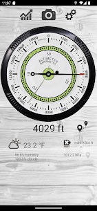
The professional altimeter with automatic altitude detection that works even without an internet connection!
With the professional altimeter application you will be able to know the real altitude of the place where you are. It automatically shows the altitude through a complex algorithm that uses three detection methods together:
– Via satellite triangulation (functioning even without internet connection)
– Through the altitude on the map by taking the altitude of the land from your position
– Through the pressure sensor (if present) calibrated with the nearest weather station
Very accurate graphics proposes an analog altimeter (in meters or feet) with digital measurement.
Here are some features:
– Automatic altitude measurement (possibility of manual setting even with one of the three measurement methods [Map Altitude, Flight Altitude, GPS Altitude])
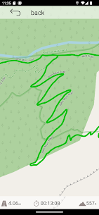
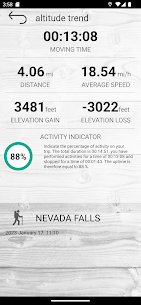
– History function with memorization of the route on the map and altitude difference graphs [also works when the app is closed] with indicators of speed, average speed, increase in altitude.
– Alert system to send your position in case of need by message or SMS
– Indication of weather forecast with trend, temperature and humidity measurement
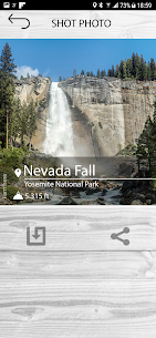
– Photos with superimposed data, location and altitude
– Custom widget to insert in Home
With the Premium additional function you can:
– Turn off advertising
– Remove watermark from photos
What's new
- new graphs on the route (speed, average speed indicators, increase in altitude and percentage of activity performed)
- saving routes with all data (altitude trend, map positions, average speed data, altitude variation)
- added satellite histogram chart
- Bugfixes and optimizations
Images

")
")
")
")
")