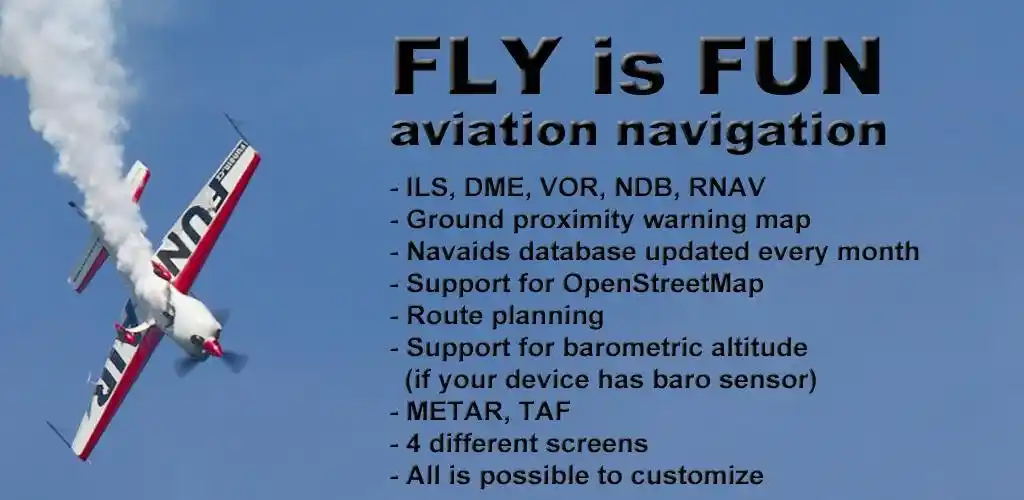
FLY is FUN Aviation Navigation
MOD INFO
- Unlimited Version Unlocked
- No Key Needed
Description
FLY is FUN is designed by pilots for pilots. FLY is FUN simplify flight preparation and improve situation awareness during flight, providing information on airspaces, reporting points, position on moving map, elevation, frequencies, railway, weather info … facilitate access to airfields related PDF document. The application also displays NOTAMs and data from rainfall radars.
FLY is FUN simulates ILS approach, VOR, NDB, DME, Marker beacons, RNAV navigation, and Marker beacons warnings, without ILS/VOR/NDB/RNAV equipment on board.
You can test FLY is FUN for free for few days. At the end of the trial period, the pilot is invited to subscribe and pay an annual fee. By doing it, he gets the right of using the application “as it is” and contributes to the development effort.
FLY is FUN Features
– Creating and modifying routes using “drag and drop”, “rubber band”
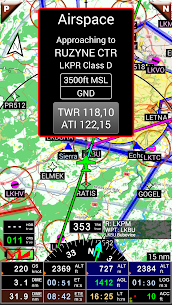
– Getting warnings, alarms, and radio info before entering controlled or special use airspaces, approaching points
– Performing route planning, evaluating distance, time, and fuel consumption (depending on wind and aircraft characteristics)
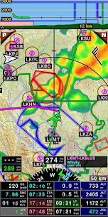
– Displaying route, bearing, trace on moving map
– Visualizing airspace
– Getting dynamic terrain map (colors depending on elevation above ground level)
– STRATUS support
– Creating and exporting Flight Plan
– Creating and exporting Flight log
– Creating, importing, or exporting routes, waypoints, RWY, airspace (Garmin .gpx, .kml, txt, OpenAir)
– Recording the flight and playing it back with Google Earth
– Sunset / Sunrise
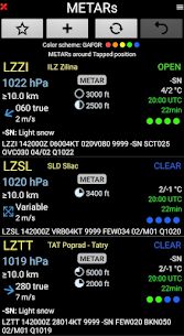
– Getting weather forecast along the route
– Rainfall radar
– Wind displaying
– Calculating the distance between 2 points on the map
– VACs
– Notepad
…
All main screens (5 portraits and 5 landscapes could easily be customized. The pilot can choose from around 100 values to display. Example:
– Altitude GPS or barometric
– Ground speed
– Bearing
– Vertical speed
– DME to next point/destination
– Estimated time to next point/destination
– Time since the departure
– Stop watch
Information could be customized too depending on users’ preferences (VFR, IFR, IFR, and VFR) and zoom level. The more you zoom IN, the more detail, information, waypoints,.. you see
Logbook
The integrated logbook allows recording:
– Duration since departure time
– Departure and arrival time
– Departure and arrival airport
– Flight track (it is possible to export it as .kml or .gpx and to replay it)
– Used aircraft
– Pilot(s) and copilots in charge
– Distance, average speed, maximum speed
Navigation data available from the open-source database are updated according to AIRAC cycles.
Charts and elevation data
Free charts and elevation data are available for most countries and could be imported directly via the application store.
Other charts could be created and imported by the pilot itself or made on request available as commercial service.
Pilots could select the most appropriate charts: free open-source charts as well as commercial charts as ICAO, Cartabossy, SkyVector, FAA sectional, and terminal charts…
VACs and PDF files
VAC and AIP Infos are available for more than 50 countries
User can easily attach your own PDF files.
Usage of external GPS connected via Bluetooth is possible
User guide: http://www.funair.cz/downloads/manuals/flyisfun.pdf
If you have any suggestions to improve this application or you find some bug please visit www.flyisfun.com
Use this application for VFR FLYING ONLY!!! We are not responsible for any use of this application.
Images


Related apps


Recent Updates
-
Updated
 GoodShort MOD APK (Premium Unlocked)3.0.2.2102 GoodNovel 40 MB
 -
UpdatedDice Dreams MOD APK (Unlimited Dices)1.108.0.36250 SuperPlay. 340 MB
-
UpdatedDomino Dreams MOD APK (Unlimited Coins/Stars/Always Win)1.53.3 SuperPlay. 206 MB
-
UpdatedHazmob FPS MOD APK (Unlimited Ammo, No Reload)2.18.61 Hazmob 200 MB
-
NewSVPlayer MOD APK (Full Licensed)1.8.0 SVP Team LLP 58 MB
-
Most Downloaded Apps
-
UpdatedSpotify MOD APK (Premium Unlocked)9.1.52.1394 Spotify AB 100 MB
-
YouTube MOD APK (Premium Unlocked)21.21.80 Google LLC 110 MB
-
UpdatedYouTube Vanced MOD APK (Premium Unlocked, No Ads)21.21.91 Vanced Team 120 MB
-
UpdatedTikTok MOD APK (Premium, All Region Unlocked)45.3.5 TikTok PTE.ltd. 200 MB
-
UpdatedHOT51 PRO MOD APK (VIP/Room Unlocked, No Ads)1.1.999-93 HOT51 60 MB
-
Most Downloaded Games
-
UpdatedHiggs Games Island MOD APK (X8 Speeder, No Password)2.78 Higgs Games 200 MB
-
GTA 5 Unity APK (Latest)0.7 Rockstar Games 1.4 GB
-
Royal Dream MOD APK (X8 Speeder, No Ads)6.29 HIGOGAME PTE LTD 130 MB
-
Grand Theft Auto: San Andreas MOD APK (Unlimited Money)2.11.311 Rockstar Games 2.5 GB
-
UpdatedRoblox MOD APK (Mega Menu, 60+ Features)2.723.787 Roblox Corporation 200 MB
-


