GeoCam Pro APK (Full Version)
Description
GeoCam Pro by Wazar is the leading photo and video application for Android! It uses augmented reality to show on top of your camera a layer of geographical information such as Compass orientation, GPS position, and different phone inclinations like a theodolite optical instrument.
What you can do with GeoCam:
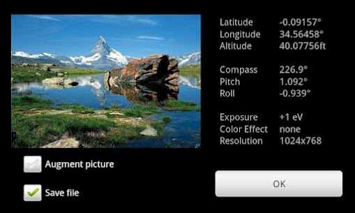
GeoPictures: an original way of storing your holiday photo album. See all your pictures on Google Maps or Google Earth on your personal computer with the export feature. Add markers with your comments on places you liked. You can share these albums with anyone who can run Google Earth, and use the EXIF GPS data stored by GeoCam to view them with any EXIF compatible application.
videos: the first app to let you record videos with an embedded layer of geographical data. A useful addition to pictures – you can see the pitch, roll, and compass orientation over time on charts.
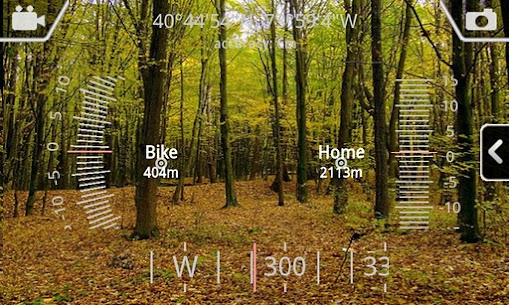
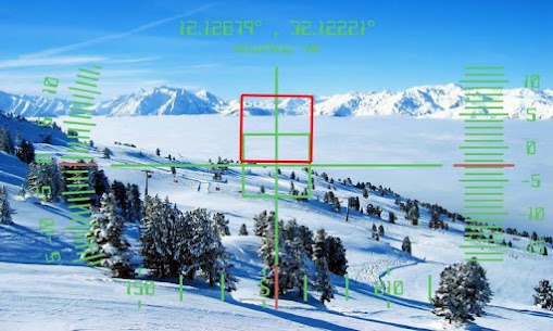
Bearings: GeoCam is an accurate measure tool. It shows your compass orientation (choose between magnetic or geographic North), your inclination and elevation with readable cursors (like a cockpit HUD). It can be used in terrain mapping, on a glide, sailing, mountain biking…
Measurements: Evaluate the distance to any object with the triangulation feature. You can also measure its height once the distance is known. This is not done by showing any unreadable cursor on the screen, but with mathematical formulas. Choose between metric and imperial measure systems.
GeoCaching: prepare a list of key places in an area and view them with your camera on augmented reality: name, distance. You will not require a data connection so it can be used when hiking abroad when visiting another city… This will help you make sure you are going in the right direction and give you the remaining distance. You can also add markers during your hike with the “Add here” option, for example, to flag the base camp, a water source, or anything interesting you find on your way.
With GeoCam Pro, you get:
No Ads
Record and playback augmented video. This is a powerful tool in addition to geophoto to record the topology of any area for further reference, as you can add your audio commentary. Augmented video is an exclusivity of GeoCam by Wazar.
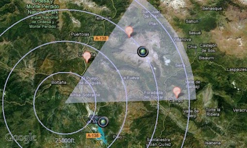
Export KMZ files to Google Earth, to display your pictures and markers in their original location and orientation, and share them easily.
Images

Related apps


Recent Updates
-
Updated
 YouTube Morphe MOD APK (Premium Unlocked)21.23.480 Vanced Team 100 MB
 -
UpdatedWallverse Wallpaper MOD APK (Premium Unlocked)3.5 The Phone Fuel 50 MB
-
UpdatedMimo: Learn Coding MOD APK (Premium Unlocked)9.14 Mimo: Learn to Code 70 MB
-
UpdatedLight Cone Music Player MOD APK (Premium Unlocked)1.1.5(bebf5546) 川陀的程序员 16 MB
-
UpdatedRegain MOD APK (Premium Unlocked)58.1.1625 EpowerX Labs 30 MB
-
Most Downloaded Apps
-
UpdatedSpotify MOD APK (Premium Unlocked)9.1.52.1394 Spotify AB 100 MB
-
YouTube MOD APK (Premium Unlocked)21.21.80 Google LLC 110 MB
-
UpdatedYouTube Vanced MOD APK (Premium Unlocked, No Ads)21.21.91 Vanced Team 120 MB
-
UpdatedTikTok MOD APK (Premium, All Region Unlocked)45.3.5 TikTok PTE.ltd. 200 MB
-
UpdatedHOT51 PRO MOD APK (VIP/Room Unlocked, No Ads)1.1.999-93 HOT51 60 MB
-
Most Downloaded Games
-
UpdatedHiggs Games Island MOD APK (X8 Speeder, No Password)2.78 Higgs Games 200 MB
-
GTA 5 Unity APK (Latest)0.7 Rockstar Games 1.4 GB
-
Royal Dream MOD APK (X8 Speeder, No Ads)6.29 HIGOGAME PTE LTD 130 MB
-
Grand Theft Auto: San Andreas MOD APK (Unlimited Money)2.11.311 Rockstar Games 2.5 GB
-
UpdatedRoblox MOD APK (Mega Menu, 60+ Features)2.723.787 Roblox Corporation 200 MB
-


