Planit Pro: Photo Planner APK (Patched/Full)
PlanIt Photo Inc.Released on
Aug 7, 2013Updated
Dec 13, 2023Size
86MVersion
10.4.18Requirements
5.0Downloads
10,000+Get it on
MOD INFO
No LP or Google Play Modded needed.
Description
Planit Pro is a special call to landscape photographers, travel photographers, nature photographers and those who are interested in night photography, city photography, time-lapse, star-trails, milky way or astro-photography: look no more, this is the ultimate app for you – the Planit Pro. It only costs you a cup of Frappuccino but will save you tons of time and effort and a lot of gas money. Most importantly, it will make you enjoying landscape photography even more.
")
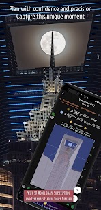
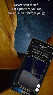
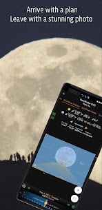
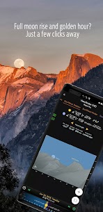
Ansel Adams dedicates the beginning of his first book “Taos Pueblo” to visualization. He introduced the idea of “previsualization”, which involved the photographer imagining what he wanted his final print to look like before he even took the shot. Of course, there are many great photos which were taken impromptu. However, for landscape photographers, being able to previsualize the scene before going there will greatly reduce the chance of being caught unprepared and will greatly increase the chance of getting better shots.
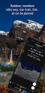
Photographers use various tools to help them pre-visualizing the scene. Nowadays, many of those tools are phone apps. Planit Pro is an all-in-one solution that is designed to leverage the map and simulated viewfinder technologies to provide the necessary tools for photographers to pre-visualize the scene in combination with the ground subjects and the celestial objects such as the Sun, the Moon, Stars, Star-trails and Milky Way.
In the Planit Pro app, we packed it with features – from location scouting such as GPS coordinates, elevations, distance, elevation gain, clear view, focal length, depth of field (DoF), hyperfocal distance, panorama and aerial photography, to the Ephemeris features such as the sunrise, sunset, moonrise, moonset time and direction, twilight time, special hours of the day, sun/moon finder, major stars, constellations, nebulae azimuth and elevation angle, star trail planning, time-lapse calculation and simulation, sequence calculation and simulation, milky way searching, solar eclipse and lunar eclipse, exposure/ND filter calculator, light meter, rainbow position prediction, tide height and tide search etc. All the information are either represented on the map as an overlay or visually presented in simulated viewfinders (VR, AR, picture, or street view), just like you look through your camera’s viewfinder. Whatever you want for your landscape photography, it is there in the Planit Pro.
Landscape photography is an adventure in the nature world. We understand sometimes there won’t be any network connection when you are out exploring. Planit Pro was designed for have it in mind. If you preload the offline elevation files and the offline mbtiles maps, you can use the app fully offline without the need for network connections.
What's new
We will resend the verification email if the account is not yet verified when the user tries to login or reset password.
Only show the past task markers within a year on the map.
Added a setting button on the top left of the map, tap to open map category settings, press and hold to open all settings.
Added a show/hide markers added by you setting which allows you to hide all the markers so that the map content is fully visible.
Menu - Version History has complete change logs.
Images
")
")
")
")
")