eWeather HDF – weather app MOD APK (Pro Unlocked)
| Developer | Elecont software |
| Released on | Jul 10, 2018 |
| Updated | May 31, 2024 |
| Size | 20M |
| Version | 8.8.8 |
| Requirements | 7.0 |
| Downloads | 1,000,000+ |
| Get it on | |
MOD INFO
- Pro / AdFree features unlocked;
- Disabled / Removed unwanted Permissions + Receivers + Providers + Services;
- Optimized and zipaligned graphics and cleaned resources for fast load;
- Ads links removed and invokes methods nullified;
- Google Maps Location works;
- Google Play Store install package check disabled;
- Debug code removed;
- Remove default .source tags name of the corresponding java files;
- No activation code required;
- Languages: Full Multi Languages;
- CPUs: universal architecture;
- Screen DPIs: 120dpi, 160dpi, 240dpi, 320dpi, 480dpi, 640dpi;
- Original package signature changed;
Description
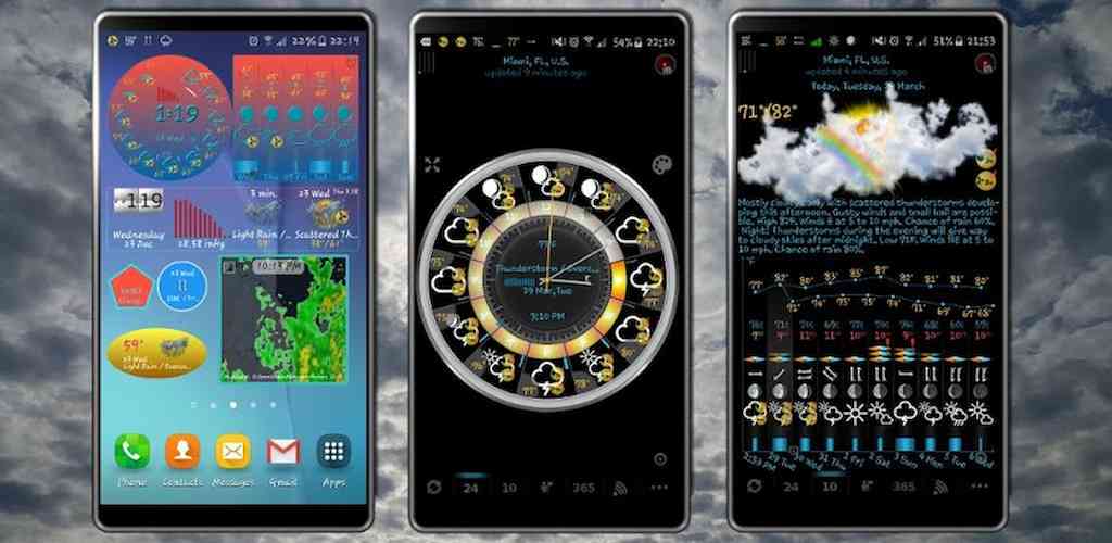
eWeather HDF is a weather app with an accurate weather forecast and barometer. Unique weather widgets include weather clock widget, storm radar widget, sun and moon widget, barometer widget, weather alerts, moon phase, earthquake widget, ten day forecast etc.

The high accuracy of the forecast is achieved by using two reliable meteorological agencies, a large number of meteorological stations and unique information processing.
Barometer app: both atmospheric pressure and sea level pressure. Barometric pressure tracker informs you about pressure changes in the past and future 24 hours. Rising pressure leads to the sun. Pressure drop leads to rain.
Fishing barometer: Graph of pressure changes combined with sunrise and sunset, moonrise and moonset, hourly forecast of rain and wind with tides table helps to predict fishing weather.
The sea and air temperature, precipitation and cloud cover for any place in the world are in a few years archive. The travel weather helps you to choose the right time and place for the upcoming trip and compare the current temperatures and precipitation in this year and the past years.
Earthquake app: earthquake map with earthquake alert notifications filtered by magnitude, depth and distance from your location. Earthquake tracker data provided by the USGS.
Our app displays icons for temperature, precipitation, and barometric pressure in the status bar. You can add notifications for wind, earthquake, humidity, UV index, geomagnetic storm, moon phase filtered by low or high threshold, etc.
Severe weather alerts, tornado tracker, hail probability, heavy rain and wind alerts are provided by National Weather Service (NWS) & NOAA. Hurricane tracker and typhoon information are provided by GDACS.
The app can be used as a home weather station with an analog or digital clock. It is very convenient to use an old phone or tablet that is no longer needed by hanging it on the wall or placing it on a stand.
The lunar calendar displays the lunar day, moon phases, sun and moon eclipses. The moon calendar widget has sunrise and sunset times, solar and lunar eclipses, spring and autumn equinox, summer and winter solstice, daylight hours, times before sunset and sunrise, etc.
The hourly forecast includes not only temperature and precipitation, but also air humidity, wind speed and direction, dew point, visibility on the roads, perceived temperature and even a METAR report.
An hourly forecast of the level of ultraviolet radiation (UV index ) allows you to correctly plan how much and when you can be in the open sun to avoid sunburn.
Precipitation map shows weather radar (for the US and Japan) with real data and future forecasts. The weather map has a variety of layers including a wind map, temperature map, satellite images, etc. The NOAA radar widget can be any size from 1×1 to 5×5. The radar app makes rain radar forecast up to 60 minutes.
Space weather is available as a geomagnetic index with geomagnetic storm alert.
Ice warning and freshly fallen snow will help you in the evening to be aware of possible problems that may occur in the morning while driving.
The air quality app contains the concentration of ozone (O3), fine (PM25) and coarse (PM10) particulate matter, dioxide (NO2) and nitrogen oxide (NO), carbon monoxide (CO) etc. from various sources: AirNow, Copernicus, ECMWF, etc.
The tide app provides tide tables for some locations. Sea temperature is given based on measurements from buoys and satellites.
The app collects location data to display current conditions for your current location in the status bar and widgets, even when the app is closed or not in use.
With our app, you’ll always know exactly what the local weather will be like in the coming week.
What's new
Added temperature graph for last 24 hours
Some errors were fixed and the user interface was improved


