Accurately Measure Distances, Areas, and Elevations with Maps Measure
Effortlessly Calculate Distances and Areas on Google Maps
In today’s world of location-based services, precise measurements are crucial for various tasks, from planning outdoor projects to calculating travel distances. Maps Measure is a lightweight and user-friendly app designed specifically for measuring distances, areas, and even elevations directly within the familiar Google Maps interface. This comprehensive guide will explore the key features, functionalities, and benefits of Maps Measure, ensuring you can leverage its power for your individual needs.
A Simple and Intuitive Interface for Effortless Measurements
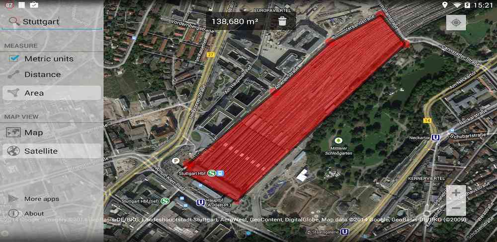
Maps Measure provides a straightforward approach to calculating distances and areas. The app’s intuitive design prioritizes ease of use, making it accessible to users of all technical levels. Simply open the app, select the desired location on the Google Maps view, and tap to mark points. Maps Measure automatically calculates the distance and area between these points, displaying the results clearly for immediate use.
Key Features for Accurate Results
Maps Measure’s core functionality revolves around its ability to measure various aspects of geographical locations. The app allows users to calculate:
- Distances: Whether you’re planning a hike or need to determine the driving distance between two points, Maps Measure easily computes the linear distance between any selected points.
- Areas: Calculating areas is equally straightforward. Simply select multiple points to define a polygon, and the app calculates the area enclosed within those points. This functionality is invaluable for surveying land, measuring plots, or simply determining the size of a park or field.
- Elevations: Beyond simple distances and areas, Maps Measure also provides elevation data. Knowing the elevation differences between points is crucial for various applications, from planning outdoor activities to understanding terrain changes.
Flexible Units and Diverse Map Views
Maps Measure offers flexibility in units, enabling users to view calculations in either imperial (feet, miles) or metric (meters, kilometers) units. This adaptability caters to a global user base and ensures compatibility with various measurement standards.
The app also provides a range of map views, including:
- Standard Map: A classic Google Maps view for basic navigation and location identification.
- Hybrid: Combines standard map data with satellite imagery for improved visual clarity and contextual understanding of the terrain.
- Satellite: Provides a purely satellite-based view, ideal for detailed visual analysis of landscapes and structures.
- Terrain: Offers detailed elevation data, providing visual representations of hills, valleys, and other topographic features, crucial for hikers, surveyors, and anyone needing precise elevation information.
Seamless Integration with Google Maps
Maps Measure seamlessly integrates with Google Maps, offering a familiar and intuitive user experience. This integration allows users to leverage the extensive resources and features of Google Maps while focusing on the specific measurement task at hand.
User-Friendly Navigation and Management
The app’s interface is designed for easy navigation and management of measurement points. A simple swipe from the left side of the screen provides access to additional options for managing measurement points. Long-pressing the trash icon efficiently deletes all marked points, ensuring a clean and organized measurement session.
Supporting a Wide Range of Devices and OS Versions
Maps Measure is designed to be compatible with a wide range of mobile devices and operating systems. This commitment to compatibility ensures access to precise measurement tools for a broader user base.
Performance and Optimization for Mobile Devices
Designed with mobile optimization in mind, Maps Measure prioritizes speed and responsiveness. The app is lightweight, minimizing strain on device resources while ensuring smooth performance, even on older devices.
Privacy and Security Considerations
Maps Measure prioritizes user privacy and security. The app operates with minimal permissions, only accessing the necessary data required for measurement functions. This commitment to user privacy assures users of the responsible handling of their data.
Conclusion
Maps Measure stands as a powerful and user-friendly tool for calculating distances, areas, and elevations within Google Maps. Its intuitive interface, comprehensive features, and mobile optimization make it an invaluable asset for a wide range of users. Whether you’re a hiker, surveyor, or simply someone looking for a convenient way to measure distances, Maps Measure simplifies the process, ensuring accurate results every time.


